A warm and humid early summer is forecast for New Zealand, with some regions facing a heightened risk of heavy rainfall over the coming months.
Earth Sciences New Zealand (ESNZ) has released its latest Seasonal Climate Outlook, putting an 80 percent probability on La Niña conditions persisting through November to January. Principal scientist Chris Brandolino outlined the broader shift under way: the stormy, unsettled weather that dominated the past two months is giving way to more settled conditions, before east to northeast winds drawing down from the tropics and subtropics take hold.
Speaking on Morning Report, Brandolino identified the second week of November as a period to watch. A significant area of low pressure over the Tasman Sea is expected to bring a fresh bout of active weather arriving from the west and northwest.
"It could bring some really heavy rain for parts of the country... We'll see what that unfolds, but it's going to be unusually warm. We're probably going to get a period of pretty wet weather," he said.
"Looking ahead to the next week or two, there'll be a pretty big area of low pressure over the Tasman Sea, and that may put areas like the upper South Island and parts of the North Island under the gun for some heavy rain."
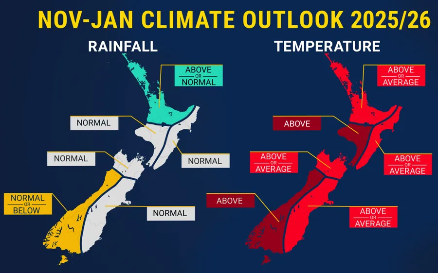
Brandolino acknowledged there is still a lot of uncertainty over what the season will look like, but the overall picture points toward above-normal rainfall, higher humidity, and rising temperatures across parts of the country. The upper North Island is of particular concern, with Bay of Plenty, Auckland, Northland, and Coromandel all expected to receive wetter than usual conditions. Humidity will also increase, most notably overnight and across the North Island generally.
Average or above-average temperatures are anticipated across all regions, with the exception of the western flanks of both islands, where above-average warmth is the most likely outcome. The west of the South Island should see normal or below-normal rainfall from November through to January.
La Niña and El Niño are opposite phases of a global climate cycle that shapes rainfall, temperature, and wind patterns worldwide. ESNZ notes that while the phenomenon influences New Zealand's climate, it typically accounts for less than 25 percent of seasonal variability here. During La Niña, unusually strong easterly winds churn cold deep-sea water to the surface between South America and the central Pacific, cooling that stretch of ocean.
Brandolino explained what this means locally: "With La Niña we tend to have more east to north east winds and when you get an air flow coming from the sub tropics to the tropics you're going to get warm because air is coming from there but you're also going to have that moisture and that does increase the odds for those big rainfall events particularly the upper to eastern part of the North Island."
On average, La Niña steers more northeasterly winds toward New Zealand, bringing wetter weather to the northeastern North Island while leaving the lower and western South Island comparatively drier. ESNZ is forecasting below-normal soil moisture and river flows for the east of the North Island, and near or below normal for the north of the North Island and east of the South Island.
"We haven't pivoted quite yet we are in the process of making that motion if you will so there's still going to be some lingering effects."