Boxing Day ranks among the biggest days on the water all year. Ramps fill before sunrise, beaches pack out quickly, and anchorages that were quiet the night before can be shoulder-to-shoulder with vessels by mid-morning. This year, that familiar summer rush arrives alongside a significant weather warning, and one that deserves more than a passing glance.
Severe Thunderstorm Watches and Heavy Rain Watches are active across large portions of both islands. Not every corner of the country will see severe conditions, but the atmospheric setup is the kind where things can deteriorate sharply, particularly as the afternoon and evening progress. Anyone on the water, at the beach, or covering distance by road today should treat this information seriously.
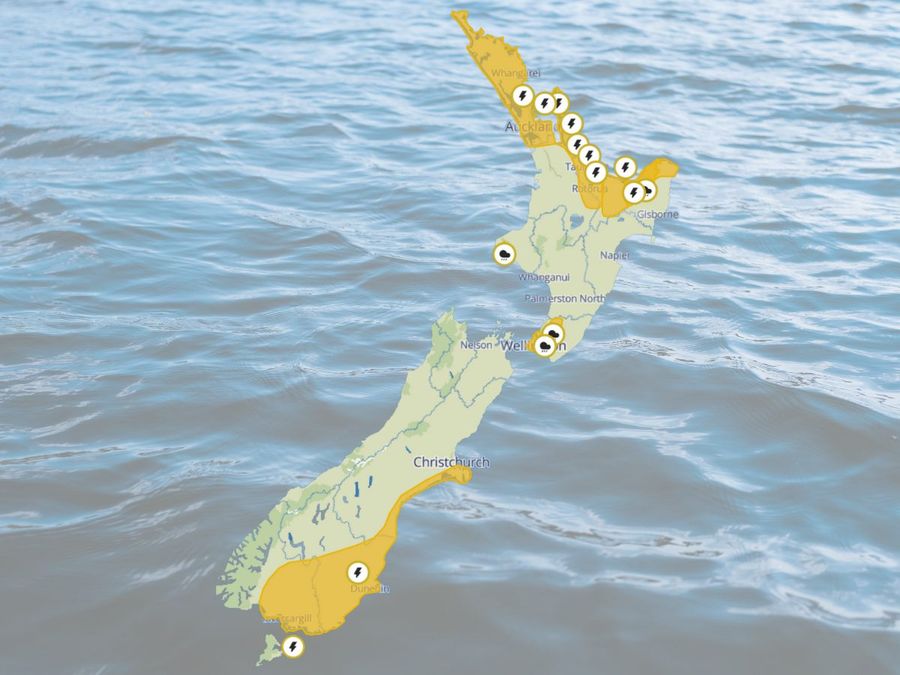
The upper North Island carries the most immediate risk. Northland, Auckland, Great Barrier Island, the Coromandel Peninsula, western Bay of Plenty and Rotorua are all sitting under a Severe Thunderstorm Watch running through until this evening. A moist, unstable air mass is combining with a complex trough forecast to track east across the region. The primary hazard is not prolonged rain but rather its intensity, with short, sharp downpours of 25 to 40 millimetres per hour considered possible.
That rate of rainfall overwhelms stormwater systems quickly, produces surface flooding in short order, and can reduce visibility to almost nothing within seconds. On the water, the consequences are familiar to experienced skippers. River mouths and entrance bars become considerably more dangerous when rain and wind combine, floating debris appears without warning, and wind direction can shift abruptly near a thunderstorm. Narrow channels and busy holiday anchorages amplify all of these risks.
Heavy Rain Watches are also current for parts of the Bay of Plenty, Taranaki Maunga, the Tararua Range and Wellington, with a front expected to push north overnight. In areas close to ranges, there is a moderate chance that some of these watches are upgraded to full warnings.
The hazard profile across the South Island differs. A cold, unstable air mass is driving thunderstorm development from early afternoon, and a Severe Thunderstorm Watch is in place for Christchurch, the Canterbury Plains and High Country, North Otago, Central Otago, Dunedin, Clutha and Southland, running through until 8pm. Development is expected to be most pronounced along coastal Canterbury south of Banks Peninsula, eastern Otago and Southland, where there is a moderate risk of some storms reaching severe intensity.
The standout threat in this part of the country is large hail, with stones larger than 20 millimetres considered possible. Hail of that size can shatter windscreens, damage vehicles and create hazardous road surfaces in an instant. On the water, a hail squall typically arrives with little forewarning and can strip visibility to almost nothing within seconds. Anyone anchored in an exposed location or considering a late return should weigh up their options well before conditions force the decision.
A Severe Thunderstorm Watch indicates that atmospheric conditions are favourable for storms to reach severe thresholds, but it does not mean severe weather is certain or that every location within the watch area will be affected. What it does signal is that preparation and awareness are warranted. In New Zealand, a thunderstorm is classified as severe when it produces rainfall of 25 millimetres per hour or more, hail of 20 millimetres or larger, wind gusts exceeding 110 kilometres per hour, or damaging tornadoes or waterspouts.
The practical response is straightforward. Watch the sky and watch the wind. If conditions start shifting quickly, the right call is to act early rather than hold on and see what develops. Heading back to the ramp ahead of schedule, moving to a more sheltered anchorage, or clearing exposed beaches and headlands before a cell arrives are all preferable to waiting until the situation forces your hand.
MetService radar and short-term forecasts are particularly useful on days like this, and it pays to check them regularly through the afternoon and into the evening rather than relying on a single morning update. Surface flooding, reduced visibility and spray are likely on the roads as well, so the challenges do not end when you leave the water. Civil Defence guidance for conditions of this kind recommends planning ahead, keeping well away from flooded areas, and giving fast-rising water a wide margin at all times.