Spotting a life raft or a drifting canoe somewhere in the vast open Pacific ranks among the most demanding tasks in search and rescue. Even with powerful assets like the RNZAF's P-8A Poseidon, the combination of enormous distances, deteriorating weather, and tiny targets can reduce the most professional operation to a desperate gamble.
The SAR4SAR project, short for Synthetic Aperture Radar for Search and Rescue, was conceived to shift those odds. Its underlying idea is straightforward enough: give any small vessel in trouble a reliable way to become visible to satellites overhead. The science and engineering behind that idea, though, draw on some genuinely clever New Zealand thinking, space technology, and a welcome streak of practical ingenuity.
Rather than depending entirely on emergency beacons or radios, SAR4SAR is developing compact radar reflectors light enough to be stored on almost any boat, quick enough to deploy in seconds, and effective enough to be detected from orbit. Once in the water, each device bounces radar energy emitted by low Earth orbit satellites straight back skyward, producing a vivid signature on Synthetic Aperture Radar imagery. Because SAR operates through cloud cover, complete darkness, and even wildfire smoke, it gives rescue coordinators a 24/7, all-weather method of fixing a vessel's position, potentially well ahead of when any visual search could succeed.
From concept to real-world testing
New Zealand's Defence Science & Technology group, known as DST, leads the programme alongside the University of Auckland's Space Institute and Institute of Marine Science.
The first trials, conducted on land at the university's Ardmore field station in late 2024, pitted six commercially available reflectors against two novel designs developed by the team. Satellites gathered radar data across two to three weeks, measuring which designs returned the strongest and cleanest signals. Those results effectively de-risked subsequent sea trials by identifying which shapes and materials performed best before the more demanding conditions of open water.
Phase 2A testing followed in February 2025, with five of the top-performing designs evaluated north of Omaha Beach. Deployed from the university's research vessel Te Kaihopara, the reflectors were assessed across buoyancy, durability, and satellite detectability. Early results were positive, producing clear detections and generating useful information to guide further design improvements ahead of more rigorous conditions.
Beating the elements in the sub-Antarctic
The project's true test came with HMNZS Canterbury's Operation Endurance voyage to New Zealand's sub-Antarctic islands in March 2025.
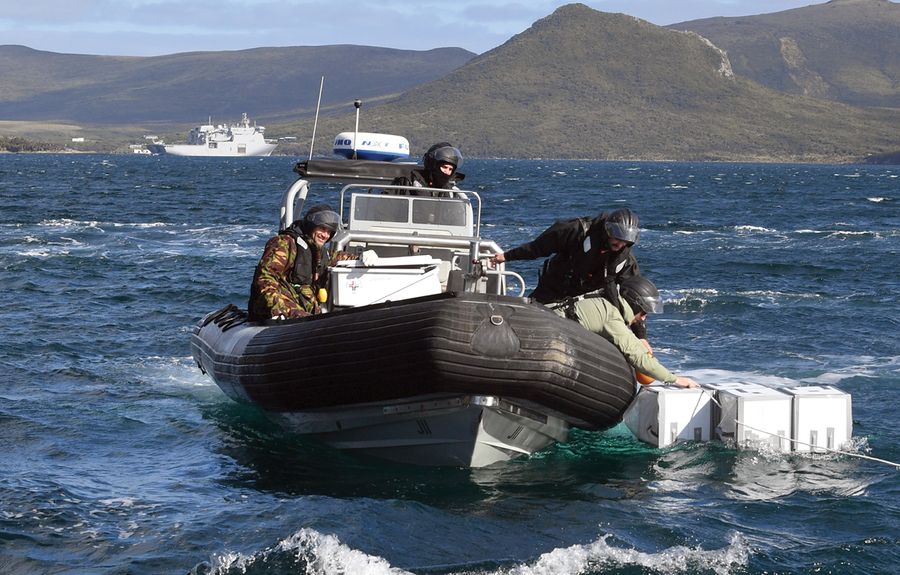
DST and University of Auckland scientists deployed reflectors from Navy RHIBs into seas driven by 50-knot winds. The devices self-expanded into three-dimensional forms that held their shape and remained upright through the punishment of those extreme conditions. Each one registered as a distinct, bright point on satellite radar imagery, standing out clearly against the surrounding ocean surface.
That ability to survive and perform in severe weather sits at the heart of what the project is trying to achieve. As Dr Tom Dowling, one of the project leads, puts it: "We aim to make the needle so shiny that it can't be missed."
Low cost, high impact
Affordability is among SAR4SAR's most compelling qualities. Modern emergency beacons and communications equipment are effective, but they remain out of reach for many people, particularly in remote Pacific Island communities where access to safety equipment is limited.
The project's patented reflector design could be manufactured for around $60. Built from accessible materials including aluminium foil, plastic sheeting, tarps, and gaffer tape, the reflector relies on geometry to do the real work. Precisely angled aluminium surfaces concentrate and return radar energy efficiently, generating a signature clear enough for trained AI analysis systems to identify without confusion.
Dr David Galligan, Director of Defence Science and Technology, articulates the humanitarian dimension plainly: "Many people in the Pacific go to sea with limited safety equipment. This could give them a much better chance of being found."
The AI advantage
Satellite SAR imagery covers enormous areas, and sorting through it quickly enough to help people in imminent danger demands more than human eyes alone. SAR4SAR is integrating artificial intelligence tools capable of scanning incoming radar data, flagging potential distress signatures, and delivering accurate position information directly to rescue coordinators.
That level of automation reduces false alarms, speeds up the response chain, and makes better use of expensive assets such as long-range patrol aircraft, which carry significant costs to operate and keep in service.
Looking ahead
With Phase 2 trials wrapped up, attention now turns to a further programme of testing in sheltered coastal waters near Auckland during June and July 2025. This work will focus on refining reflector shapes, dimensions, and materials before Phase 3 trials, where operational realism will be the primary measure of success.
SAR4SAR is not intended to replace beacons or radios. As a low-cost backup or accessible alternative, however, it could prove transformative, particularly within New Zealand's search and rescue zone, which stretches across some 30 million square kilometres of ocean.
Home-grown innovation, advanced satellite capability, and AI-driven analysis are steadily bringing that potential within reach. Should the project fulfil its promise, the next time a fisherman, a sailor, or a paddler disappears beyond the horizon, their chances of making it home will be meaningfully better than they are today.