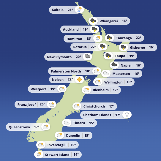
Issued 10:00 am Saturday, 3 January
A slow-moving low is crossing the upper North Island this Saturday, 3 January, bringing unsettled and at times dangerous conditions. Rain, thunderstorms, and sharply reduced visibility are the main threats for anyone on the water today. A ridge building from the west and south will gradually improve things overnight, but the hours ahead carry real risk, particularly for boaties.
*Upper North Island*
Severe thunderstorms have already broken out across parts of Auckland and Waikato. Through the afternoon and into the evening, showers across the upper North Island, from Northland south to Waitomo, Taupō, and the Bay of Plenty, will intensify. Some will turn heavy and thundery, delivering short bursts of torrential rain, localised surface flooding, and sudden drops in visibility. Conditions ease once night falls, and tomorrow should bring partly cloudy skies with a few afternoon showers.
The most serious rain risk lies across Gisborne and Hawke's Bay, where heavy falls are expected at times and thunderstorms remain possible through to early Sunday. Warnings remain current for these areas. The ranges are likely to record the highest totals, and anyone in the region should watch for rapidly rising streams, slips, and difficult driving conditions.
*Central and lower North Island*
From Taranaki through to Wellington, including Taihape and Wairarapa, cloudy skies and scattered showers will dominate. Taranaki could see heavier downpours and a rumble of thunder this afternoon before the west clears this evening. Overnight and through Sunday, most of these areas turn mainly fine.
The Wellington coast presents its own hazards today. Strong southerlies will drive a rough sea along the south coast and through Palliser Bay in particular. Winds ease on Sunday and the sea state settles through the day.
*South Island*
Nelson and Buller through to Fiordland are largely fine today, with inland showers the main feature. Nelson may see a heavier burst and the occasional clap of thunder. Tomorrow turns more cloudy with a few isolated showers developing. The remainder of the South Island stays mostly cloudy, with isolated showers clearing for a time before returning to Southland and Otago tomorrow afternoon as a weak front moves through.
*Chatham Islands*
Cloudy skies and light showers are expected today, clearing tomorrow morning.
*Coastal and boating outlook*
A ridge is building over the South Island while the low tracks east of the North Island. High pressure will spread north tomorrow and settle over many areas. A front is then expected to approach Fiordland late Tuesday before weakening as it crosses the South Island on Wednesday.
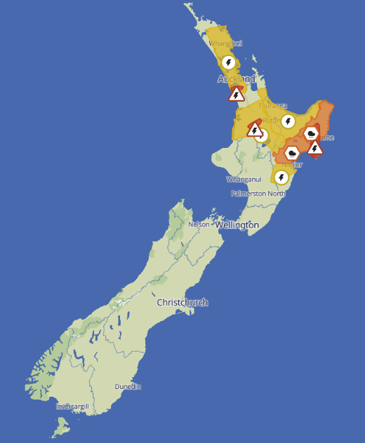
Severe thunderstorm warnings and watches are in place across large parts of the North Island this afternoon and evening. Boaties should stay off the water in any warned area. Those already out should head for shelter early, well before conditions deteriorate. Exposed headlands, river mouths, and bars should be given a wide berth until the threat has passed.