
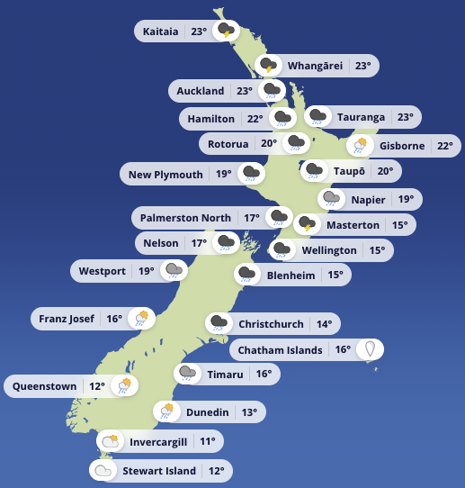
A low-pressure system crossing the Tasman Sea is driving this week's unsettled weather, pushing toward central New Zealand today. A warm front has stalled over central districts while a cold front advances from the west. Both features slide eastward on Friday, after which a ridge of high pressure builds in from the southwest on Saturday, bringing a cooler southerly flow. A more substantial high settles over the South Island on Sunday and extends across the North Island by Monday.
Conditions are sharpest at the southern end of the country. Puysegur carries a Gale Warning today, with southeast winds of around 20 knots early rising to 35 knots north of Puysegur Point by morning. Seas build to very rough, and a long-period southwest swell sits at around three metres before easing later. Friday brings little relief, with southeast winds holding near 25 knots and southerlies surging to 35 knots north of West Cape in the morning. Sea state in the north remains very rough, making these difficult waters for small craft and uncomfortable aboard larger vessels.
In the upper North Island, a Strong Wind Advisory covers the Hauraki Gulf, Coromandel, and the Bream Head to Cape Colville corridor. Northerlies begin at around 15 knots this morning, building to 20 knots gusting 30 knots, then lifting to 25 knots gusting 35 knots later today before shifting northwest this evening. Seas turn rough through the afternoon and evening. Visibility drops in showers, and thunderstorms are possible from morning in the Hauraki Gulf and the Bream Head to Colville sector, with the risk extending to Coromandel later in the day. By Friday, conditions ease. Bream Head to Colville trends northwest at 20 knots, falls to light variable in the morning, then turns southwest later. The Hauraki Gulf sees northwest winds of 20 knots swing to southwest 10 knots in the morning as showers clear. Coromandel sits in a northerly of around 20 knots before shifting northeast then westerly, with showers also clearing through the day.
Hawke Bay is likewise under a Strong Wind Advisory. Winds begin light, but a northeast breeze of 20 knots develops late morning and strengthens to 25 knots gusting 35 knots for a period this afternoon. That eases to a northerly of 20 knots gusting 30 knots before dropping to around 15 knots by evening. Seas become rough for a time. Showers reduce visibility and thunderstorms are possible, mainly in the afternoon. Southerly swell runs at roughly one metre and holds near that level on Friday as the wind swings from easterly to southerly.
Friday stays unsettled, with showers over the North Island easing later and rain in the South Island's east accompanied by heavy falls before improving. Saturday becomes noticeably better for most regions as the ridge arrives. Sunday looks broadly settled under the developing high, though cloud and scattered showers may persist across parts of the north and east of the North Island.
The Chatham Islands carry a more active outlook through this period, with spells of rain that could be heavy and thundery, easing to showers Friday night before clearing early Sunday. Strong northerlies turn to strong southerlies on Saturday afternoon and ease through Sunday.
For anyone planning to head out today or tomorrow, squalls within showers, sudden gusts near the front, and rapid increases in sea state in open water are all genuine risks. Shortening the trip, staying in familiar waters, or waiting for the high to settle conditions later in the weekend are all worth considering.