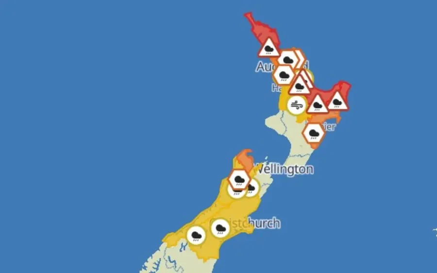
This is the latest weather advice from MetService. A strong and extremely humid northeasterly flow precedes a tropical low that is forecast to approach New Zealand from the north today. Heavy rain, downpours and easterly gales are expected to affect many areas. The rain and wind should ease Thursday after the low crosses the country. Red and Orange Warnings are in force for many areas. Please stay up to date with the latest forecasts.
Heavy Rain Warning - Red
Area: Northland Period: 14hrs from 9am - 11pm Wed, 21 Jan Forecast: Expect another 90 to 120 mm of rain on top of what has already accumulated, or possibly more in some localised areas, especially in the north and east. Peak rates 25 to 40 mm/h in localised downpours from this afternoon. Impact: Threat to life from dangerous river conditions, significant flooding and slips. Conditions will disrupt travel, make some roads impassable, and isolate communities. Action: Do not enter floodwaters and avoid travel. Act quickly to self-evacuate if you see rising water. Be ready for power and communications outages. Preparedness advice. Area: Coromandel Peninsula Period: 18hrs from 9am Wed, 21 Jan - 3am Thu, 22 Jan Forecast: Expect a further 200 to 250 mm of rain on top of what has already accumulated, especially about the higher ground. Peak rates of 25 to 40 mm/h in downpours from this afternoon. Impact: Threat to life from dangerous river conditions, significant flooding and slips. Conditions will disrupt travel, make some roads impassable, and isolate communities. Action: Do not enter floodwaters and avoid travel. Act quickly to self-evacuate if you see rising water. Be ready for power and communications outages. Preparedness advice. Area: Bay of Plenty including Rotorua Period: 24hrs from 9am Wed, 21 Jan - 9am Thu, 22 Jan Forecast: Expect a further 180 to 240 mm of rain on top of what has already accumulated. Peak rates of 25 to 40 mm/h in downpours from Wednesday evening. Note that downpours may affect any part of the area. Impact: Threat to life from dangerous river conditions, significant flooding and slips. Conditions will disrupt travel, make some roads impassable, and isolate communities. Action: Do not enter floodwaters and avoid travel. Act quickly to self-evacuate if you see rising water. Be ready for power and communications outages. Preparedness advice. Area: Gisborne from Tolaga bay northwards Period: 26hrs from 9am Wed, 21 Jan - 11am Thu, 22 Jan Forecast: Expect a further 250 to 350 mm of rain on top of what has already accumulated. Peak rates of 25 to 40 mm/h in downpours from late this evening. Impact: Threat to life from dangerous river conditions, significant flooding and slips. Conditions will disrupt travel, make some roads impassable, and isolate communities. Action: Do not enter floodwaters and avoid travel. Act quickly to self-evacuate if you see rising water. Be ready for power and communications outages. Preparedness advice.
Heavy Rain Warning - Orange
Area: Tasman west of Mapua Period: 18hrs from 4pm Wed, 21 Jan - 10am Thu, 22 Jan Forecast: Expect 80 to 120 mm of rain. Peak rates of 10 to 20 mm/h expected. Low chance of upgrading to a Red Warning. Impact: Streams and rivers may rise rapidly. Surface flooding, slips, and difficult driving conditions possible. Action: Clear your drains and gutters to prepare for heavy rain. Avoid low-lying areas and drive cautiously. Preparedness advice. Area: Auckland and Great Barrier Island Period: 17hrs from 9am Wed, 21 Jan - 2am Thu, 22 Jan Forecast: Expect 80 to 120 mm of rain with the largest accumulations in the east and about Great Barrier Island. Peak rates of 25 to 40 mm/h in downpours in the east and about great Barrier Island expected from about noon today. Low chance of upgrading to a Red Warning. Impact: Streams and rivers may rise rapidly. Surface flooding, slips, and difficult driving conditions possible. Action: Clear your drains and gutters to prepare for heavy rain. Avoid low-lying areas and drive cautiously. Preparedness advice. Area: Gisborne south of Tolaga Bay and Hawke's Bay Period: 24hrs from 10am Wed, 21 Jan - 10am Thu, 22 Jan Forecast: Expect 100 to 150 mm of rain. Peak rates of 10 to 20 mm/h expected. Low chance of upgrading to a Red Warning. Impact: Streams and rivers may rise rapidly. Surface flooding, slips, and difficult driving conditions possible. Action: Clear your drains and gutters to prepare for heavy rain. Avoid low-lying areas and drive cautiously. Preparedness advice.
Heavy Rain Watch
Area: Waikato, Waitomo and Taupo Period: 18hrs from 9am Wed, 21 Jan - 3am Thu, 22 Jan Forecast: Periods of heavy rain, and amounts may approach warning criteria. Moderate chance of upgrading to a Warning. Area: Tasman and Nelson Districts east of about Mapua Period: 18hrs from 4pm Wed, 21 Jan - 10am Thu, 22 Jan Forecast: Periods of heavy rain, and amounts may approach warning criteria. Moderate chance of upgrading to a Warning. Area: Buller and Grey Districts Period: 18hrs from 3pm Wed, 21 Jan - 9am Thu, 22 Jan Forecast: Periods of heavy rain, and amounts may approach warning criteria. Moderate chance of upgrading to a Warning. Area: Canterbury Period: 19hrs from 6pm Wed, 21 Jan - 1pm Thu, 22 Jan Forecast: Periods of heavy rain, and amounts may approach warning criteria. Moderate chance of upgrading to a Warning. Area: Westland District Period: 18hrs from 3pm Wed, 21 Jan - 9am Thu, 22 Jan Forecast: Periods of heavy rain, and amounts may approach warning criteria. Low chance of upgrading to a Warning.
Strong Wind Watch
Area: Auckland and Great Barrier Island Period: 14hrs from 9am - 11pm Wed, 21 Jan Forecast: Easterly winds may approach severe gale in exposed places. Moderate chance of upgrading to a Warning. Area: Waikato, Coromandel Peninsula, Waitomo and Taupo Period: 18hrs from 9am Wed, 21 Jan - 3am Thu, 22 Jan Forecast: Easterly winds may approach severe gale in exposed places. Moderate chance of upgrading to a Warning.
- All information from MetService