A heavy rain warning covering the period from 11 am to 11 pm on Wednesday is in place for Bay of Plenty and Gisborne/Tai Rāwhiti north of Ruatoria and the inland ranges, with thunderstorms and downpours also possible across those areas.
MetService has issued a severe thunderstorm warning for the Rodney, Gulf and Albany districts. Just after 1 pm, the agency's weather radar picked up severe thunderstorms near Warkworth, Puhoi, Kaukapakapa, Kaipara Flats and Ahuroa. Tracking southeast, those storms were expected to reach Orewa, Whangaparaoa and Silverdale around 1.37 pm before arriving near Auckland and the Inner Hauraki Gulf by 2.07 pm. MetService warned that very heavy rain would accompany the activity.
Reports also emerged of a tornado passing through a motor camp in rural Manawatū and overturning a caravan. Emergency services received the call at 12.36 pm, and Fire and Emergency confirmed at least one person had been injured.
📡Radar update⛈️ More heavy showers are building over Northland. Matamata recorded a whopping 43mm of rain in an hour this morning. pic.twitter.com/mjqOLBfOr2 — MetService NZ (@MetService) December 2, 2025
MetService meteorologist Mmathapelo Makgabutlane described the Bay of Plenty warning as the most notable of the day, with rainfall totals of between 80 and 120 millimetres expected before nightfall. "With thunderstorms in the mix, we could see shorter periods of more intense rain bringing those possibilities such as flooding, as well as slips and difficult driving conditions." Makgabutlane added that thunderstorms were also possible in Taranaki and Whanganui.
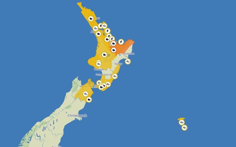
A severe thunderstorm watch is in place from 1 pm to 6 pm Wednesday for a broad sweep of the North Island, taking in the Coromandel Peninsula, Waikato, Bay of Plenty and Taupo. Some of those storms may intensify during the afternoon, bringing localised downpours of up to 40 mm/h, large hail and wind gusts reaching 90 km/h. MetService noted a slight chance of a tornado, though thunderstorm activity was forecast to ease by Wednesday evening. Northerly winds are expected to swing southwesterly, again with gusts of up to 90 km/h.
Heavy rain watches span a wide range of locations throughout the day, including Northland, Auckland, Great Barrier Island and the Coromandel Peninsula, Taranaki, Wairarapa, the eastern hills and ranges in Wellington, and central North Island areas such as Waikato and inland Whanganui. Strong wind watches are also in force later on Wednesday for Northland, Auckland, Taranaki, Horowhenua to Wellington, parts of the Tararua and Hawke's Bay districts, and Wairarapa.
In the South Island, heavy rain watches are current for the Kaikōura Coast and the Chatham Islands, which also carries a strong wind watch. Thunderstorms are possible over Central Otago on Wednesday afternoon or evening, and wind watches cover Marlborough and parts of the Nelson region from 5 pm Wednesday through to 3 am Thursday.
Makgabutlane said conditions were expected to improve from Thursday onwards.