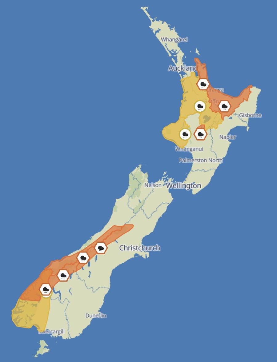
The severest conditions this week centre on Fiordland and the southwest, with storm-force winds and very high seas making those waters genuinely dangerous. A progressive deterioration sweeps from north to south across Tuesday and Wednesday, bringing heavy rain, building swells and freshening winds to much of the country.
Northland, Auckland, Coromandel, Bay of Plenty and Gisborne are all sitting under a developing northeasterly flow at present, with conditions set to worsen noticeably from Tuesday. Through today, winds across the northern waters are light to moderate out of the northeast and seas remain slight, though that picture shifts rapidly. By Tuesday evening, Coromandel coastal waters will be under a Strong Wind Advisory, with northeast winds climbing to 25 knots and gusting to 35 knots as seas turn rough. Bay of Plenty falls outside the coastal warnings for now, but the strengthening northeast flow will still make exposed coasts and headlands uncomfortable.
Swell across the upper North Island currently sits around 1 metre from the east, but a northeast swell building to around 2 metres is expected by Tuesday, particularly north of East Cape. Wind-against-tide situations will produce steeper, choppier seas, and boaties working the shallow banks of the Hauraki Gulf or the Tauranga Harbour entrance should be especially watchful.
Heavy Rain Warnings are in place for the Coromandel Peninsula and Bay of Plenty from Tuesday afternoon through Wednesday. The Coromandel is forecast to receive 140 to 160mm, while Bay of Plenty could see 150 to 200mm. Rainfall of that scale will push rivers and streams hard, strengthening outflows at bar crossings and cutting visibility sharply during the heaviest falls. Late Tuesday through to early Thursday will bring messy seas, increasing swell and hazardous conditions across much of the upper North Island.
Monday is largely fine across the western North Island from Waikato through to Taranaki, but occasional rain arrives from Tuesday afternoon. No marine warnings are currently issued for this stretch of coast, though freshening northerlies, short-period wind waves and periodically reduced visibility can be expected. A Heavy Rain Watch covers the wider Waikato region, with accumulations approaching warning levels on Tuesday and Wednesday. River mouths and harbour entrances in the area may be affected. Taranaki will experience a similar sequence: periods of heavy rain, a northerly wind trend, and the exposed west coast bearing the full force of the offshore pressure gradient. Choppy seas and the possibility of stronger gusts in squalls are both worth factoring in.
Fine weather lingers a little longer across the lower North Island, but rain tracks south on Tuesday evening. Northerlies freshen ahead of the approaching trough, and while no swell warnings have been issued for Wellington or Wairarapa, Cook Strait will see increasing northerly-quarter winds generating lumpy, confused seas around tide changes. Hawke's Bay and Wairarapa sit on the eastern flank of the system, with rain setting in on Tuesday night. Seas there will be moderate but messy under the northerly influence. No Heavy Rain Warning is current for the lower North Island, though localised rainfall could still be significant enough to affect bar entrances and visibility.
Nelson and Marlborough can expect cloudy periods today and scattered rain tomorrow. Winds remain below warning thresholds, but Cook Strait will feel the northerly flow funnelling between the islands with characteristic sharpness, particularly when that northerly meets an outgoing tide. Swell on the eastern side stays moderate, though west-facing coasts, including the outer Marlborough Sounds, may pick up some bounce from the Tasman.
On the West Coast, the weather turns significantly heavier. Buller and Westland see the first major shift from Monday evening, with showers giving way to heavy rain in Westland overnight and continuing through Tuesday. A Heavy Rain Warning is in force for Westland, with 150 to 200mm forecast in an 18-hour period on Tuesday and isolated locations potentially receiving more. Rivers rise quickly in this terrain and bar conditions will become treacherous. Northwest swells build substantially through Tuesday as well, with exposed sections of the West Coast facing swells of 3 to 4 metres. Seas will be very rough, and stronger gusts within the northerly flow will make conditions worse still.
The most hazardous marine conditions in the country this week lie across Fiordland, particularly around Milford and Puysegur.
At Milford today, northeast winds are building to 40 knots and rising to 50 knots by evening, with seas becoming high and a northerly swell climbing to around 5 metres. Tuesday brings northeast winds at 45 knots before a shift to northwest at 25 knots in the morning, easing to 15 knots later in the day. Seas ease slowly, but the 5-metre swell reduces only gradually and is joined by a building 2-metre southwest swell.
Puysegur is worse again. Today sees northerly winds of 50 knots west of West Cape rising to 60 knots this evening, with very high seas and a northwest swell rising to around 5 metres. On Tuesday, northerlies of 55 knots ease to northwest 25 knots in the morning before rising again to 40 knots by evening. Large swells persist, with the southwest swell holding near 2 metres. Storm warnings, very high seas, heavy rain and large long-period swells occurring simultaneously represent a genuinely dangerous combination.
Southland and Otago can expect scattered rain developing on Tuesday, with coastal waters open to the wider Tasman gale belt. South of Stewart Island, swells build under the northerly and northwesterly flow, and Foveaux Strait will see short, steep seas at its northern end. Canterbury stays relatively sheltered initially, though high cloud thickens on Tuesday, and any swell effects there will be driven mainly by wind waves rather than long-period systems.
The deterioration moves from north to south over the next 48 hours. The upper North Island contends with northeast winds rising on Tuesday, heavy rain for Coromandel and Bay of Plenty, and a northeast swell increasing to 2 metres. Central New Zealand faces freshening northerlies, choppy Cook Strait conditions and patchy rain through Tuesday and Wednesday. The West Coast deals with heavy rain and 3 to 4 metre northwest swells in very rough seas. The deep south sees rising swells and strengthening northwesterlies building through Tuesday. Fiordland and Puysegur remain in a class of their own, with storm-force winds, 5-metre swells and very high seas making them the most hazardous waters in the country this week. For boats in Fiordland and along the West Coast in particular, this is a stay-tied-up pattern. Warnings continue to evolve and should be monitored closely.